MO Tested: Garmin zumo XT GPS Review

An essential navigation tool for the traveling rider
The Garmin zūmo XT is the company’s top-of-the-line motorcycle-specific GPS. While the Garmin Montana 700 series has gained popularity within the adventure-touring community, I opted for the zūmo XT to review for a couple of very specific reasons. Although the Montana 700 has built-in inReach communication capability, I opted to combine the zūmo with the Garmin inReach Mini 2 ( reviewed here) because I decided that, even though the combined cost was higher, I would rather have the inReach device on my person in case I got separated from my bike in a crash. The other feature of the zūmo that swayed me towards it was the updatable database of motorcycle shops that is included. Being out in an area without cell service and having the capability to plan a trip to the nearest bike shop, particularly in the Southwest where there are significant distances between cities, seemed like a good thing to have.
Garmin zūmo XT
+ Highs
- Bright, clear display
- Works well with gloves
- Easy to mount/remove from bike
– Sighs
- No USB-C (USB Mini? Really?)
- Water can occasionally trigger the screen
- Vulnerable to theft because it is so easy to remove
Major Features
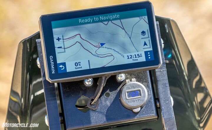
The first thing you notice about the zūmo XT is the bright, clear, 5.5-in. screen. It really is impressive, and the glossy glass screen, contrary to what you might expect, is much clearer than the last zūmo GPS I used. What you can’t see by looking at it is the IPX7 rating it carries. What this means is that the XT is capable of being submerged under three feet of water for up to 30 minutes, which means it should be perfectly capable of handling use on a motorcycle in a driving rain.
When it comes to impacts, the zūmo XT has survived the MIL-STD-810 drop testing requirement of being dropped 26 times, on all faces (sides), corners, and edges. So, one expects that the XT would survive the forces generated by crashing in the dirt or dropping your bike in a parking lot.
Strangely, however, the X in the rating means that no claims of dustproofness are made about the device. One would think that for a GPS that is being pitched towards adventure riders, resistance to dust would be a major selling point. Regardless, the seriousness with which Garmin approached designing the XT is reflected in the shape of the power cradle and the snugness with which the unit attaches to it. This snugness, I must note, makes it almost impossible to feel the latch click into place, thereby prompting me to try to pull it free from the cradle every time just to be sure.
On the subject of mounting the zūmo XT, the package includes a handlebar clamp to affix the Ram-Mount-style ball-mount system that supports the cradle. So, this arm is compatible with any other ball mount you may already have on your bike. To increase the mounting options, the cradle itself has an AMP mount hole pattern, meaning that there are a number of other GPS mounting options available. (I chose to mount my test unit on the Adventure-Spec Mini Fairing Support utilizing these holes.)
While Garmin claims that the built-in lithium-ion battery can power the unit at 100% brightness for 3.5 hours, I chose to install the included motorcycle power cable to switched power on the bike. A $50 accessory auto mount kit is available, though it is clearly an afterthought to the unit’s design because it requires that you plug in a USB cable every time you mount it – and that cable’s connector is a mini-USB! What is this the 1990s? The lack of the more current and convenient USB-C connection is a pretty glaring oversight on such a well thought-out GPS.
Depending on which continent you purchase your zūmo, it will come with both the street maps, topographic maps, and other POI/location information for your location preloaded on its 32gb internal storage. While the maps and system take up roughly half of the internal storage, I opted to install a 256gb microSD card in the available slot to check out how it integrated into the system. Once the card was formatted by my Mac to MS-DOS FAT 32, the operative description would be “seamlessly.” But I’m getting a little ahead of myself.
The first time I turned on the zūmo XT, it prompted me for a Wi-Fi connection and, once logged in, proceeded to update the firmware and all the maps to the latest version. Every time it is shut down when logged into my home network, it checks for updates prior to powering off. The unit comes with lifetime map updates, so I assume that eventually I will be asked if I want to apply another update.
User Interface
While performing the initial setup of the zūmo XT, I was impressed with how much more sensitive the screen was to my fingers than the previous zūmo I owned several years ago. With the (several generations) older zūmo, I had to actually press on the screen for my inputs to register. With the XT and bare fingers, my clicks occasionally registered before I even touched the screen. I have since tried the screen with gloves of varying thickness, and they all worked. However, winter gloves required a little longer contact with the screen to get their inputs to register.
Still, you’ll probably want to take off your gloves for entering more than a few characters simply because the keys on the keyboard are quite small. Yes, there is an option for larger keys that is automatically enabled when you first set up the XT, but then you have to click a button to see the other half of the keyboard, sometimes making you type almost double the necessary keystrokes. A quick trip to the keyboard setting solved that maddening issue.
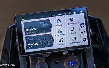
The home screen itself will be instantly recognizable by anyone who has ever used a Garmin GPS before. Just about every icon on the screen (save a couple of the tiny ones on the top status bar) can be used to reveal a submenu. I’ll touch on the ones that I use the most. However, I’ll start with the coolest one, though it doesn’t get used that frequently.
In the left third of the status bar, you’ll see a motorcycle (or, possibly, a car or knobby tire). If you tap on it, the Usage Mode window opens and allows you to switch to one of three modes, motorcycle, car, or off-road. The cool part is that each mode has its own settings, allowing any changes you make to the interface to be for that particular mode. For example, my Motorcycle Mode settings have the map set to the street map, but in Off-Road Mode, the topographic map is shown. You can even use different pointers to represent your location in each mode (though the only ones that you can instantly tell the direction of are the pointers). I’m sure that over time my settings for street and dirt will get refined so that they are quite different.
The button you will use the most is the Where To? one, which takes you to a window rife with options – 17 options, to be exact. So, Cool Feature Number Two is necessary here. If you press and hold on any of the icons until the highlight color turns off, you can drag and drop it to a new position, giving you the ability to place your most-used items in the six that are immediately viewable.
More often than not, if you’re like me, you’ll go straight to the search box at the top right of the screen. This allows me to type in my search term, business name, or address most like I am accustomed to on my smartphone.
For the rest of the screen, I’ve placed Fuel Prices as my one-tap gas station locator and Motorcycle Locations because I wanted to test its accuracy. Sadly, if you’re in a pinch, you should probably call before you go to one you’re not familiar with. The database still lists my favorite salvage parts shop that closed down a couple of years ago.
If you follow the View Map button from the main screen, you’ll go to the map of your current location, and you shouldn’t be surprised to learn that it is quite customizable, too. Click on the three stacked dots on the bottom right, and you’ll be presented with the option to stop the route, edit the route, mute the audio, or several other options. Clicking on the wrench in the top left allows you to customize the buttons displayed on the map during navigation. Very handy! Play around on the map screen, and you’ll learn that clicking the Status Bar reveals turn-by-turn directions. Also, clicking the speed on the bottom left, gives you access to the dual trip meters and a variety of data fields.
Apps Menu
From the main screen, clicking the Apps button takes you to a window with 21 options. Some are more useful than others, and as with much of the XTs flexible interface, others can be accessed in other places, too. As with the Where To window, the button order is customizable. So, the options you will never use can be dropped out of sight.
Starting at the top as it is from the factory: Having the Owner’s Manual was vital on my first couple of test rides with the zūmo XT. Any device with this many uses and customizations will have a learning curve. The inReach button paired the XT to my Garmin Mini 2 and would even allow me to send messages or trigger an SOS.
The BirdsEye Direct function was something I hoped to use to fill up my microSD card with satellite imagery of my planned journey on the CABDR. While Garmin has made this free, rather than its previously paid service, the interface for downloading images is so clunky as to be almost unusable. This is the biggest disappointment of the zūmo XT. If there were a way to download the images for a couple of miles on either side of a saved track with the XT, BirdsEye Direct could be extremely useful to adventure tourers. As it stands, it is a missed opportunity. Instead, I used Garmin’s BaseCamp software to download the BirdsEye imagery, a slow task but one I think will be useful when looking at terrain to scout potential areas to camp.
Some riders will use the trip planner, and others will not. Still, the interface is as intuitive as using the Where To button. You just program in a start point and a destination. Then you can add in (or not) the interim locations you want to hit on the way there. Here is where the fun begins. Once you set your start and finish, you have the option of choosing Adventurous Routing on a sliding, four-position scale, with 1 being most direct and 4 being significantly twistier roads. While researching the zūmo before ordering a test unit, I read a few reviews that took Garmin to task for not finding the absolute best roads in their area. I find it kind of silly to expect the algorithms on a 5.5-in. device to pick out all the gems that only come with local knowledge, but I’ll posit that when traveling in an unfamiliar area and looking for a fun ride on the spur-of-the-moment, I would find it satisfactory. Still, I doubt that I’ll change my semi-obsessive multiple map apps and motorcycle road website use that characterizes my tour planning.
So, just to test this theory, I loaded in some waypoints from my spring tour, cranked Adventurous Routing to 11, and awaited the results. No, the zūmo didn’t plot the exact same trip, but it did manage to route me over some of the fun roads I selected. Although it routed me over the Tail of the Dragon, it stubbornly refused to take me on the Cherohala Skyway, despite a couple of interim location changes. If you want to know the truth, I’m kind of glad. I’d hate to deny myself the hours of fun planning a tour.
The Tracks button shows you the tracks you’ve saved from your travels or those you’ve imported. However, since it connects to the Collections feature used by other Garmin devices and saved in your account in the Garmin Cloud, you’ll want to develop a good naming scheme to keep things organized.
Fuel Settings powers an interesting Motorcycle/Off-Road Mode feature. Once you set your bike’s range, you can have the XT give you low-fuel warnings and suggest fuel stops based on your bike’s range.
The Smart Notifications app allows you to control how many (or few) interru…notifications will appear on the maps screen. You’ll want to click this and the wrench on the next screen and marvel at all the things that Garmin thinks you might want to have pop up while you’re riding. Health and fitness? Business and finance? Entertainment? No thank you. Incoming calls and text messages? That depends…
The last item I want to look at, although there are many more, is traffic. When the zūmo XT is paired to a smartphone and the Garmin Drive app is running, the XT has access to traffic information that is updated roughly every minute. When your route is initially planned, a pop up on the right side of the screen will notify you if there will be any delays along the planned route. During your travel, if the traffic conditions change, you are notified in the same way. Also, based on your selection in the Traffic settings, you will either be asked if you want to update your route to avoid the congestion or have it done automatically. The lack of this feature in previous generation GPS models is what kept me (and, I assume, many users) using a phone in a harsh environment for which it wasn’t designed for so long.
Bluetooth Integrations
If you’ve ever paired a Bluetooth communicator or headphones to your smartphone, setting up a zūmo XT is as easy as a couple of clicks. However, there is one caveat. In order to hear the GPS’ turn-by-turn directions, both your phone and helmet communicator must be paired to the zūmo. If your communicator is paired directly to your phone, you lose that functionality. Because of this mode of pairing, I was initially afraid that I would lose “Hey, Siri” access, which I use quite a bit while riding, but it works just fine. (Perhaps, the credit goes to my Cardo PackTalk Edge, or maybe it’s a Cardo/Garmin team effort. Either way, it works.)
The zūmo’s voice prompts are clear and offer an interesting variety of phrases. The directions are explicit, saying which lanes to be in and what the relevant road names are. In fact, Garmin has set up the XT so that its voice prompts vary a bit, giving not just details about stop lights but, in some cases, noting landmarks at the intersection. If I had to pick nits, my one issue is pretty minor: the voice doesn’t sound as human as Siri and feels more machine-like. While there is a more natural voice available, you have to give up little details, like street names in the audio instructions, to use it.
GPS Use
While this may feel like I’m saving the most important feature for last, the way riders interact with the GPS function of the zūmo XT is affected by all of the features covered to this point. Once I changed the settings to allow the full keyboard to appear on the screen, I found that entering addresses was pretty well split 50/50 between using the GPS screen and the Drive app on my iPhone. However, if I needed to copy an address from an email, I’d just copy and paste it into the app every time, making using the zūmo effectively as easy as using my phone.
For fun, I even mounted up my iPhone next to the zūmo XT to see how their street directions compared. In most cases, the directions were essentially the same. The iPhone, however, seemed to have an edge when it came to reacting to traffic during a route, giving me a warning sooner than the Garmin. This should come as no surprise when you consider that the iPhone is a networked computer with a GPS function and the XT is a self-contained GPS with networking and traffic monitoring added on. (I’m also going to assume that Apple has access to more traffic information sources than Garmin due to its comparative corporate size.) In my time testing the XT, it redirected me around traffic issues about as frequently (at least from the seat of my pants) as my iPhone on the constantly-changing streets of Los Angeles.
Where the zūmo XT really shines, though, is when you get off the cellular network that smartphones rely on for their route planning and maps. Having all of its maps built in and having the option of purchasing more niche-use maps when you need them gives the XT the advantage here. How many of us have traveled following the directions on a smartphone that had your blue dot or arrow in the middle of a blank screen as we travel through the vast distances of the Southwest? Suppose you start to wonder how far it is to your next gas stop? With a smartphone, you’d be SOL. With the zūmo XT that is kept up to date, you’d have a reasonably good idea of where the closest station is.
And then we get to off-road use where you are following either someone else’s track or one you created at home and loaded onto the XT. To test this, I planned an overnight trip out to a remote location in the California desert between the Sierras and Death Valley. For my short adventure, I used a track I found online (to stand in for following a BDR track, since the status of the southern end of the CABDR is still not certain after the recent flooding washed out many roads). After importing the track into Garmin’s powerful-but-unintuitive BaseCamp software, I studied the track in both map and satellite form to make sure it was something I was capable of doing. I also edited out tracking points of side trips I wasn’t interested in.
Since I cut my outdoor navigation teeth on paper maps and doing compass triangulation, I decided to augment the standard topographic maps Garmin provided with the USGS California topo map. Some searching led me to the GPSFileDepot, and I downloaded the necessary map data for import into Basecamp. Garmin Map Manager took care of the details.
After all the prep was handled, I set out for two days in the desert. Once I exited the highway, I switched to Off-Road Mode, turned on the USGS map layers, and started the track. A word to the wise, you must hit the starting tracking point almost exactly or you will never officially start the track although you will be following the line. (In this situation, the Off Course field on the screen just keeps getting larger and larger.) After starting correctly, being close to it seemed to click each point off the list by simply passing close to it. While there is a skip function when following a XT-generated route, I could not find one when using a track.
One thing I liked about using the USGS topo map layers is that it gave a more visual and detailed representation of the shape of the peaks and ridges around me than the stock, allowing me to better interpret the track. Although there are no voice prompts when following a track, the screen gives you everything you need to know. You just need to check it frequently.
One fun thing I noticed was that on extremely twisty sections of the road, the track occasionally took a straight line through a series of bends. That’s because what you’re following is really a series of straight lines between the datapoints of the recorded track. (In case you’re interested, each saved track can have a maximum of 10,000 datapoints.) Sometimes, my actual path of travel was as far as 0.2 mi. from the track, but it always came back by the next datapoint. After just a couple hours following a track, I knew that I would be comfortable doing so for days.
Battery Backup
On my off-road tracking test, the wiring that I ran to the zūmo XT failed, and I didn’t have the tools I needed to fix it (shame on me). So, I used it as an opportunity to experience the battery life, and I was pleasantly surprised. My trip out of the backcountry and home was over 3 hours. Despite Garmin’s claim of 3.5 hours of battery at full brightness, the battery still showed 50% when I arrived home. Now, I doubt that it would have gone twice the time it did, but from this experience, 4 hours or more of travel time wouldn’t be out of the question.
Navigating Home
In my time with the Garmin zūmo XT, I have tried to put it through the paces of what I think the average motorcyclist would, be they commuters, sport tourers, or adventure tourers. For commuters, unless you live in a very rainy climate, I’d be inclined to stick with a smartphone in a vibration-damping mount. In a climate more prone to wet weather, the cost-benefit ratio turns in favor of the XT because of its weatherproofness. In any other riding situation where you’re likely to travel off the grid, I think the zūmo XT’s benefits more than offset the cost, particularly if you take the time to learn Garmin’s BaseCamp software.
If you’re a map-loving travel planner like me, you can massage the route you want to take to your heart’s content and transfer it to your unit. For adventure tourers, I think the zūmo XT, with its support for Garmin inReach devices (specifically, the Garmin inReach Mini 2 that you can carry on your body) and the ease with which topo maps can be integrated with your device (not to mention the motorcycle-specific databases included) make the choice a no-brainer for me. As far as typical use is concerned, I like how, when I power the XT off, it checks for firmware and map updates if it is on a WiFi network, smoothing the process of keeping your GPS up-to-date.
In closing, for motorcycle travelers, the $500 Garmin zūmo XT can play an essential role in planning and navigating your routes for extended trips. Similarly, its ability to inform you about motorcycle-related locations when you’re far from home could literally save your trip. (Just call first to make sure the database entry is valid.) If you are a touring rider or one who simply likes to explore away from your usual set of riding routes, you should take a long look at the zūmo XT. I know that I am making it part of my touring arsenal.
FAQ
Can you use a GPS on a motorcycle?
Absolutely, take a look at the Garmin zūmo XT GPS reviewed here. Ideally, GPS units designed for motorcycle use need to be able to withstand both the harsh weather conditions it will need to operate in and the extreme vibration that they are subjected to on some machines. These stresses will quickly kill your typical in-car GPS units. There are many mounting solutions for putting a GPS on a motorcycle, ranging from using the handlebar or triple clamp to specialized brackets for specific motorcycle models. Shot around, there are several motorcycle-specific GPS models.
Is a dedicated motorcycle GPS worth it?
While only you can make that decision, commuters, sport tourers, and adventure tourers have different needs. For commuters, unless you live in a very rainy climate, I’d be inclined to stick with a smartphone in a vibration-damping mount. In a climate more prone to wet weather, the cost-benefit ratio turns in favor of the XT because of its weatherproofness. In any other riding situation where you’re likely to travel off the grid, I think a GPS’ (like the Garmin zūmo XT) benefits more than offset the cost.
Additional Resources
Best Motorcycle GPS Units To Help Find Your Way
Motorcycle GPS: Why Your Phone Isn’t Good Enough
MO Tested: Garmin InReach Mini 2 Review
We are committed to finding, researching, and recommending the best products. We earn commissions from purchases you make using the retail links in our product reviews. Learn more about how this works.
Become a Motorcycle.com insider. Get the latest motorcycle news first by subscribing to our newsletter here

Like most of the best happenings in his life, Evans stumbled into his motojournalism career. While on his way to a planned life in academia, he applied for a job at a motorcycle magazine, thinking he’d get the opportunity to write some freelance articles. Instead, he was offered a full-time job in which he discovered he could actually get paid to ride other people’s motorcycles – and he’s never looked back. Over the 25 years he’s been in the motorcycle industry, Evans has written two books, 101 Sportbike Performance Projects and How to Modify Your Metric Cruiser, and has ridden just about every production motorcycle manufactured. Evans has a deep love of motorcycles and believes they are a force for good in the world.
More by Evans Brasfield











Comments
Join the conversation
I've had mine a few years. I don't work it hard enough, but really like it.
NOTHING ABOUT NEW GARMIN XT 2 ?!?!!!
SO , YOU PROMOTE ALL OLD JUNKS , FIRST .....